Trailheads and Paths, Issue 13: San Gabriel, Part II, The Gardens

12

The serene inner garden of Mission San Gabriel Arcangel  exists in four parts.  There are indeed four points in this lovely arrangement:  The Grape Arbor; the manufactory; the Peace Garden; the Tongva display.

When entering the garden, through the Mission’s Museum Store, one encounters an area that links the four points of this amazing island of serenity.  Here, it is explained how the big picture of Spanish settlement fit the work of the monks and friars into its warp and weft.

SAM_8434

An archway brings the traveler into the Peace Garden.

SAM_8435

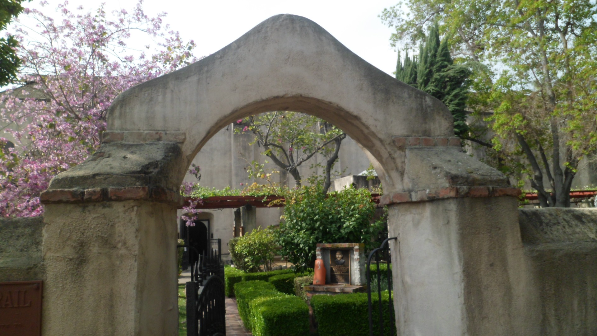
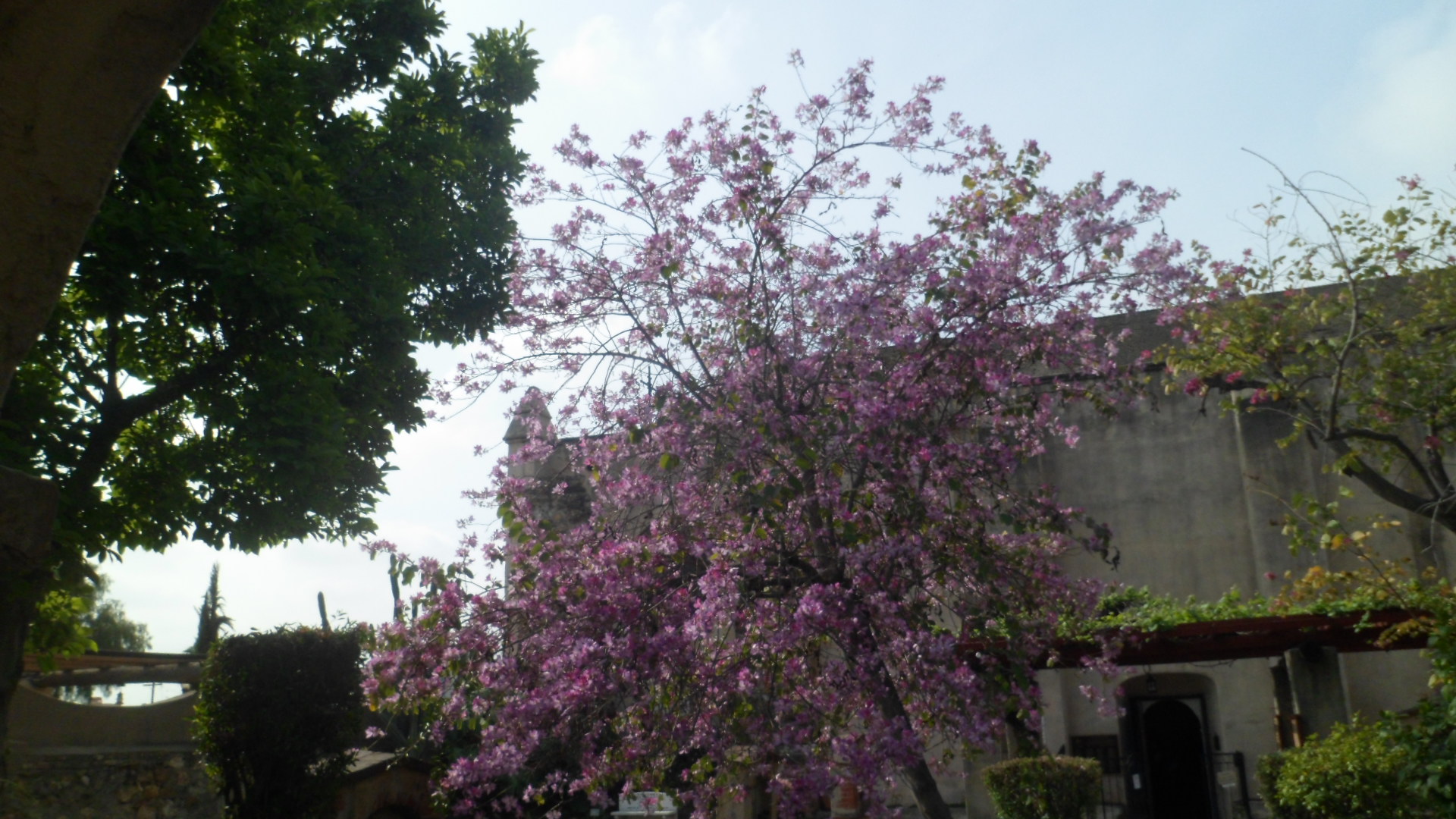
From here, it is wise to listen for any signs that there might be a Mass, or other worship activity, going on, as the Mission Church is immediately ahead, to the south.  As Mass was in progress when I walked through the Archway, I contented myself with walking about in the Tongva quadrant.  Cherry blossoms were abundant.

SAM_8436

A lion glared out from the fountain.

SAM_8437

As was the case at the Playhouse, there is a full set of  miniatures of the California missions, in this section of the garden.  Here is a miniature of Mission San Gabriel Arcangel.

SAM_8444

The garden path weaves in and out, through the various sectors.  This area, for some reason, invoked Gethsemane, for me.

SAM_8462

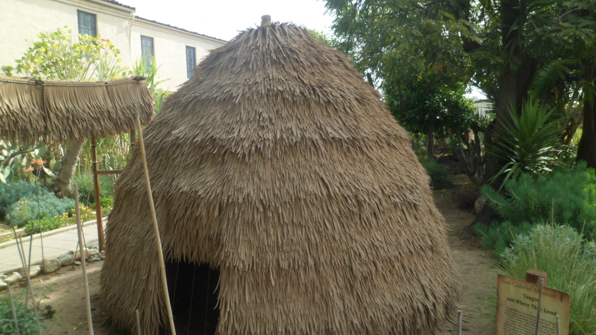
Around this corner, next to the bust of an unknown Spaniard, is the replica of a traditional home of  the Tongva, or Gabrieleno, people.  These indigenous folk dominated the Los Angeles Basin, from Malibu and Santa Monica to the area now called the Inland Empire.  A band of Tongva still lives in San Gabriel, and shares the traditional culture with interested friends and neighbours.

SAM_8468

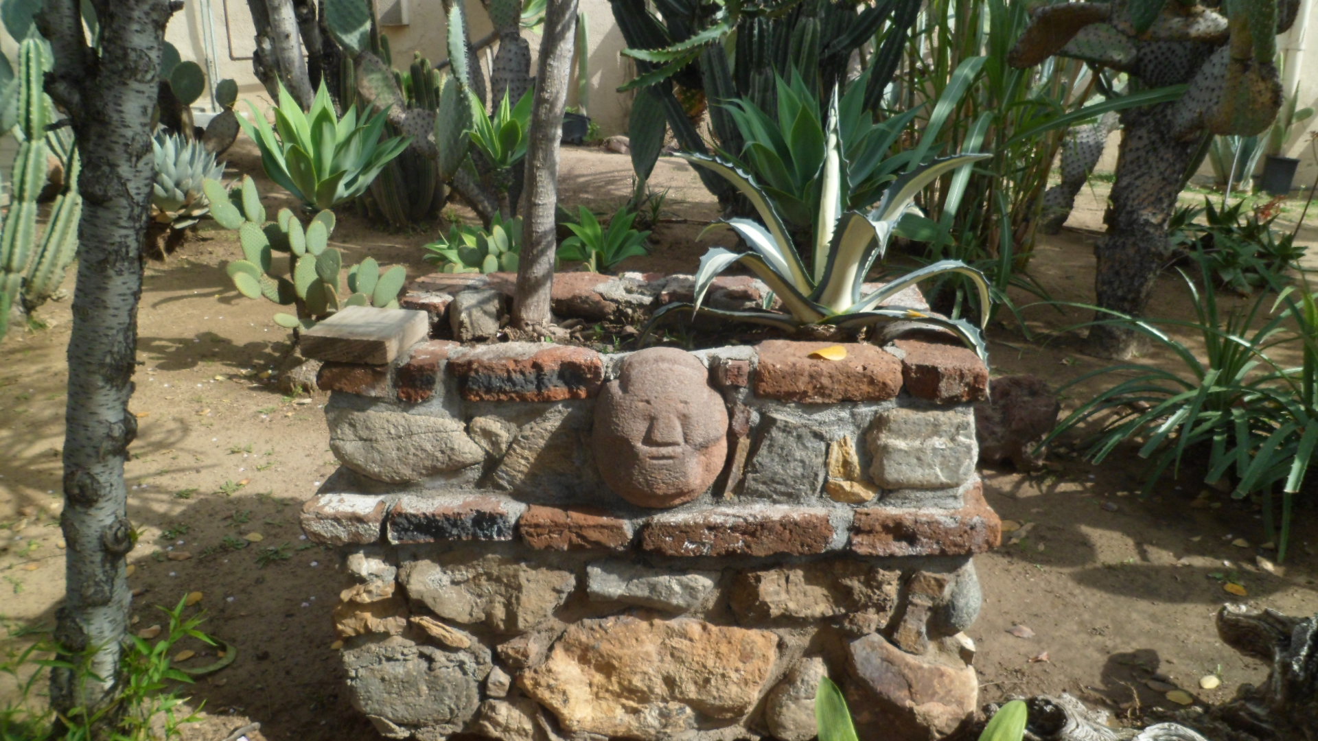
A Tongva image is featured on this nearby stone wall.

SAM_8465

From the northwest, or Tongva, quadrant, I moved into the comforting realm of Peace Garden.

SAM_8451

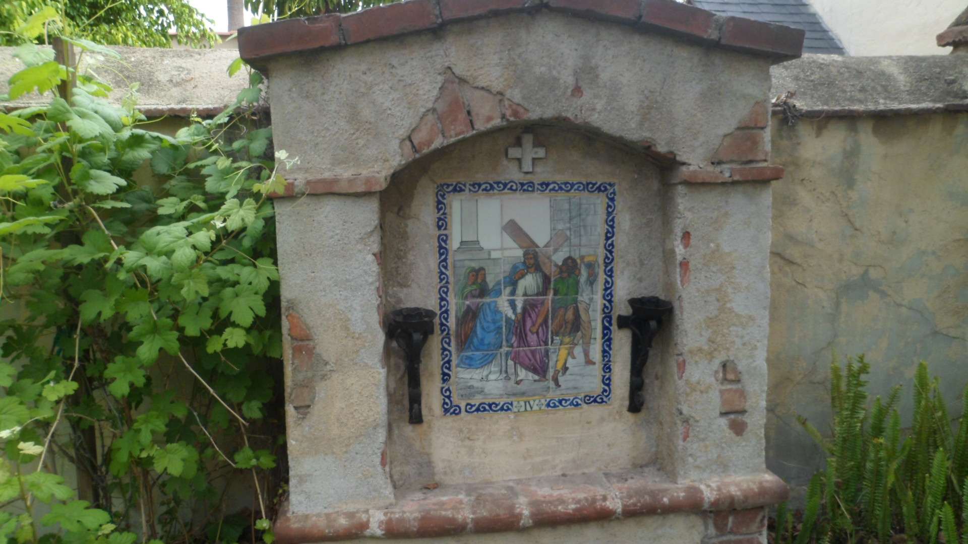
The Blessed Mother, Christ and His Stations are here, bringing into focus the closeness that God and His Messengers are always willing to have with each of us, provided we open the channel.

SAM_8439

Mary’s countenance gives solace in two places within the Peace Garden.  Here, she is addressed as Our Lady of Guadalupe.

SAM_8441

SAM_8478

The Passion of Christ is reflected in the illustrations of His Stations, such as that below.

SAM_8474

All the more so,  Christ’s Presence is felt, in this depiction of the Crucifixion.

SAM_8477

There is a very quick transition from the Crucifix to the Grape Arbor.  This small area represents the first winery in the Los Angeles Basin.    The monks initiated grape cultivation, at first to provide ceremonial wine to be used at Mass.  As with all such libations, however, pleasurable uses soon proved an incentive for wider cultivation.

SAM_8481

Padre Junipero Serra’s statue greets us here as well.

SAM_8486

Through the Cypress Arch, one is escorted into the workaday realm of the Manufactory, the northeast quadrant.

SAM_8482

Here, tallow soap, candles  and everyday implements needed by the Mission were crafted, as well as all cooked food prepared.

Below,  here is a view of the outdoor ovens.

SAM_8461

The aqueduct was fashioned from similar brick and mortar.

SAM_8459

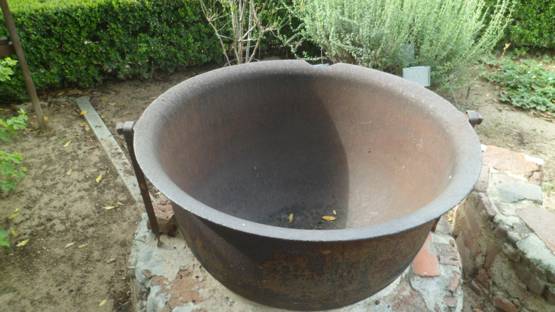
This iron cauldron was essential to the life of the community.

SAM_8460

So, of course, were soap and candles, fashioned from animal tallow, in vats such as this one.

SAM_8472

With the heat inside close to 450F, woe betided the careless and unwary of those venturing into the Manufactory.  Making the necessities of life was quite hazardous.

Life in this mission, as in other such communities, was however, generally rewarding for those of good heart.  Control of the property was batted back and forth, especially after California’s admission into the Union, in 1850.  By 183, however, the Federal government had restored control of the Mission to the Claretian Order.

On Easter, I will post scenes of the Mission Church, the Parish Church and Mission School buildings.

Trailheads and Paths, Issue 8: Where The Surfers All Go

7

I had plenty of time, after my friend Janet left, to take in Doheny Beach and the south jetty of Dana Point Harbor, before my evening visit to San Clemente.

The titular line is from an old song, “Surfer Joe”, by the Surfaris: “Down in Doheny where the surfers all go / There’s a big, bleached blondie named Surfer Joe / He has a green surfboard with a woody to match.”  Joe’s successors were not in Doheny in abundance on the delightful afternoon of Friday, March 21, but there were about five families, a lone kite flyer and two middle-schoolers, who appeared to be brother and sister.

As is my wont, I covered various aspects of the beach park, starting with San Juan Creek.  This brackish channel is the focus of a potential desalination project- quite important in an Orange County that has faced prolonged drought.

SAM_8248

SAM_8249


Of course, my attention turned to the ocean, in short order.

SAM_8246


This time around, I had my surf shoes on, so it was easy to walk about the fairly-deserted sand, and take in Doheny’s small stone jetty, and service area.

SAM_8244


SAM_8243


SAM_8240


I always have an urge to see things through to the end, so I walked over to Dana Point’s stone jetty, the dividing line between the two beaches, and walked to its western terminus.  Boulder scrambling is a good way to focus one’s heart and mind.  Along the way, I encountered a couple of families fishing, one human, the other avian.  The cormorants didn’t mind being photographed.

SAM_8304

SAM_8303


Here is what I found at the end of the jetty.


SAM_8306


To and from the end, I got different views of Dana Point’s beach front.


SAM_8301

SAM_8302


Doheny’s “dry side’ was a place of respite for some picnicking families,

SAM_8310


and a lone kite flyer.

SAM_8311


There are nesting herons and egrets here, as well.  The Nesting Tree, a melaleuca, is a Doheny Beach staple.

SAM_8293


The Butterfly Garden is the icing on Doheny’s cake.  It had only a few monarchs on March 21, but there were several birds’ nests in the eucalyptuses along the trail.

SAM_8287

SAM_8289

SAM_8295

SAM_8294

SAM_8291


There is also something magical about California coastal palms, as out of place as some find them.  They are a sign of “endless summer”, even when it’s a tad cool out.


SAM_8288


Satisfied with this day at the beach, I took in a celebration of the Divine Springtime, Naw-Ruz, at San Clemente’s Baha’i Center.

SAM_8315

SAM_8314


The following two days would also be jam-packed, with visits to three Los Angeles County beach towns, then San Gabriel and its mission, and downtown Redlands.  So, after a couple of hours with my OC Baha’i friends, I headed up a surprisingly empty I-405, to Torrance, then over to Lomita, and the comfortable little motel where I stayed on my last visit to west LA.

Next:  Manhattan Beach


Trailheads and Paths, Issue 7: Chorus of the Herons

7

Each time I have visited my son in San Diego, I stop in Orange County before heading home. The beaches, missions and gardens in the home of Disneyland and Knott’s Berry Farm have given me a far greater appreciation for all that Southern California has going for it- beyond the traffic and smog, which weren’t bad this time around, and which are only the small price we pay to enjoy the O.C’s many sublime beauties.

I have been to Dana Point twice before.  The town, named for Richard Henry Dana, whose statue adorns the town’s harbourside park, has a lovely promontory, to its north.  I have climbed the trail to the summit of that striking overlook, and walked the harbourside path, once before, as well.  This time, March 21, accompanied by my O.C. friend, Janet, I saw and heard things from a bird’s perspective, specifically that of a heron.  There are two species of heron in Dana Point and neighbouring Doheny Beach.  Janet and I witnessed a raucous chorale of nesting Blue Herons, as we walked along the harbourside park.

As is customary with our visits, we enjoyed lunch first- this time at Harpoon Henry’s, on the east end of the harbour area.  It’s hard to not get a good seafood meal in an OC beach town, and mine was fabulous.  Henry’s gave Janet a good chicken lunch as well- not every maritime-themed place does landlubber fare well, so this was a plus.

Here is a refresher of what Dana Point Harbor looks like.

SAM_8252


SAM_8253


Here, again, is the harbourside park.

SAM_8256

SAM_8260


The above photo shows a eucalyptus tree, which, along with the melaleuca (tea tree), serves as a nesting place for both the Blue Herons and their cousins, the Night Herons.

Here are some shots of blue herons and their nests.  Look carefully, and you can see the heads of one or two birds in each nest.

SAM_8261


SAM_8264

SAM_8265

SAM_8268


SAM_8275


SAM_8279

One of our avian friends decided to go for a food run.


SAM_8274

Meanwhile, back on the ground, a blond squirrel was competing with his grey California ground squirrel relatives, for the generosity of  California park goers.

SAM_8258


On the beach rocks, an oyster catcher was finding its prey.

SAM_8263

After Janet left, I lingered a bit at the south edge of the park, taking in the raucous commotion of the Night Herons, whose call sounds like a cross between someone gargling and Chewbacca the Wookie, from Star Wars.

SAM_8283

One Night Heron obliged me by sauntering in the nearby rocks.

SAM_8284

I was fascinated for the two-and-a half hours spent watching and listening to these awesome creatures.  The afternoon gave a new meaning to “Stop and smell the roses”.  There were more wisteria than any other plant, but that’s another story.

NEXT:  Doheny Beach

Black Canyon National Recreation Trail, Part 3: Drinking Snake Segment

6

I again parked at Spring Valley’s Antelope Creek Road lot, and headed south, along the Drinking Snake segment of the Black Canyon, a distance of 4.2 miles one way.  Here’s the north trailhead of Drinking Snake.

SAM_8096

The trail is a bit more rugged than the Big Bug, at the outset.  There is more volcanic debris in this area.

SAM_8099

SAM_8104

SAM_8106

SAM_8108

The views are  just as sweeping here, as they are further north.

SAM_8109

The hearts were both mineral and vegetable.

SAM_8112

SAM_8113

I arrived at an abandoned corral, water tank and windmill, near Dripping Spring, after an hour’s walk.

SAM_8115

The canyon called Dripping Spring is the north end of a longer system that runs along to Crown King Road, another 1.7 miles to the south.

SAM_8119

The hike from here is an easy rim walk, past a cow or two.  The view, though, is exhilarating.

SAM_8120

SAM_8121

Next on this trail system is the Antelope Creek segment.

SAM_8125

After making the hike back to Spring Valley, I stopped briefly at Cordes, the northernmost of four “ghost’ towns between Prescott and Black Canyon City.  It was Sunday evening, so the place was closed.

SAM_8128

My life will be topsy-turvy, in a good way, for the next five weeks, so while hiking will take a backseat to some other activities, I’m a happy blogger.

Harquahala Wilderness

6

Sunday saw my first visit to Harquahala Wilderness, featuring the highest peak in La Paz County and in southwestern Arizona.  The name, Harquahala bestowed by the Mohave people or their progenitors, means “Waterhigh up”. Harquahala Peak does get snow, every so often, though Sunday was dry and mild. I lived in nearby Salome, for a year, in the 1999-2000 Academic Year, and have passed by the entrance to this trail countless times, often wondering what the upper levels were like. I got there later than I had first planned, as an important gathering took up much of my Sunday morning. Still, the overall experience, over six hours, rivaled the best of  other wilderness experiences I’ve had in the Southwest. The first two miles of the trail are standard Sonoran Desert fare, but don’t be jaded or lulled into boredom.  There are some challenges ahead.  This experience reminded me quite a bit of the Superstition Wilderness.

SAM_8019   SAM_8020   SAM_8023

The full trail is 5.4 miles, one way.  Once through the boulder fields, the switchbacks, and fun, begin. SAM_8025

SAM_8029

Looking down into the canyon is an exhilarating experience.   SAM_8056   SAM_8059

The cathedral spire-like quality of Chimney Rock is  a motivation to keep on, with new vigour.   SAM_8060

Two-thirds of the way to the summit, some gold prospectors tried their luck, in the 1900’s.  It didn’t work out too well.  The remains of their camp are preserved here.   SAM_8070

The remnants of another Harquahala institution, an Observatory, built by the Smithsonian, and operated from 1921-1925, are found at the summit of Harquahala Peak, and are visible from the place where I chose to turn around.

SAM_8078

The summit itself was another 35-40 minutes away, and once there, the sights are worth an hour or so of exploration.  Owing to the fading daylight, and not wanting to depend on my flashlight to navigate the eastern rim’s switchbacks, I began my descent around 5 P.M.

SAM_8080

There were abundant heart-shaped rocks here, so I felt fully-blessed.

SAM_8065

As I reached the last of the eastern switchbacks, the Sun bid farewell.

SAM_8082

A night hike of ninety minutes, with my trusty flashlight, brought me back to the car.  As I reached my vehicle, the coyotes began yipping and yowling, about a mile to the east.  I will be back here someday, critters, and will get to the top, with plenty of time to do it justice.

(You probably guessed it.  The Daily Bruin didn’t take, so I am back to writing less “me-centered” fare.)

Black Canyon National Recreation Trail, Part 2: Old Sycamore Sector

4

As the day started bright and sunny, after yesterday’s intermittent rain, I heard the call of the trail loud and clear.  So, after a brief visit to the Winter Farmer’s Market, I headed to Mayer, and the northernmost segment of Black Canyon Trail.  Old Sycamore Sector stretches from just north of the culvert that goes under AZ Rte. 69, past Old Sycamore Road, to a series of rises and buttes some 3 1/2 miles to the north and east.

The first part of the trail heads up to old Sycamore Road, from Big Bug Wash, a distance of a half mile.

SAM_7964

As with the lower elevated areas of Big Bug, the native lichen is a yellow sort.

SAM_7965

The weather looked to be a bit challenging, but that doesn’t stop a true Westerner from going forth.

SAM_7966

Here, one may see the far range of the Old Sycamore area.

SAM_7969

I reached Old Sycamore Road, my northernmost attainment in the area, to date, in about 10 minutes.  The trail signs were clearly visible at this point, about two miles further east from where I had hiked previously.

SAM_7970

The trail led over and around a series of ridges, perfect exercise on a cool and windy day!

SAM_7971

Looking straight ahead, I was delighted to watch a parade of pronghorns, unfortunately not visible through the camera lens, but a joy to behold, nonetheless.

SAM_7973

Heart rocks abounded here, including one embedded in the trail- a good sign for the road ahead.

SAM_7975

About 3/4 mile from Old Sycamore Road, I found this neat little picnic spot. Here, I enjoyed an energy bar and a healthy portion of the trail mix that I put together from various items I purchased from my friends, the Kaurs- owners of The Honeyman.

SAM_7976

A gate separates the BLM area from a private ranch, and on the BLM side, there was a unique trail marker.

SAM_7979

The northern fork of Big Bug Creek offers the most heavily-wooded area on the trail.  Here there is an abundance of chaparral, mulberry and Gambel’s oak.

SAM_7980

Once past the creek bed, I found a rare pyramid rock, in the middle of the trail.

SAM_7985

The northernmost cairn on the trail had been knocked down, quite a while ago, from the looks of it.

SAM_7988

From there, the trail was less clear, and came to an end atop a small butte, looking off towards I-17 and a series of power lines.

SAM_7989

So, now my curiosity about the foothills segments of Black Canyon is satisfied.  Next, it’ll be time to gradually explore the trail from Antelope Creek Road, southwards to Carefree Highway, or vice versa.

Black Canyon National Recreation Trail: Part 1, Big Bug sector

6

Black Canyon National Recreation Trail is one of several such trails, for multiple non-motorized use, set aside by the Bureau of Land Management.  It runs about 85 miles, south to north, from Lake Pleasant Road, in north Phoenix, to an area north of Mayer, AZ.

I plan to explore the trail, a sector at a time, during the course of this year.  Careful following of a recent map led me to the south trailhead of Big Bug sector, west of the small community of Spring Valley, twenty-five miles southeast of Prescott.  The sector is 2.5 miles, one way, from Antelope Creek Road to Highway 69.

This sector is an easy hike, going through range land and some mild desert badlands, before crossing through an underpass at Hwy 69, and continuing on north, for a few miles.  I include all sectors in this series of hikes.  Some will be rather barren; others will bring out the grandeur of the Bradshaw Mountains, whose base the Trail navigates.

Here is Big Bug sector.  All trails start at the parking area, these days.  This one is about two miles west of Spring Valley, on Antelope Creek Road.  It’s a rather busy road, popular with ATV enthusiasts and those headed up into the Bradshaws.

SAM_7934

The Black Canyon Trail, though, is sparsely used, at least on this end.  I only saw three other hikers, with their dogs.

SAM_7935

I did have other company, though, on the rangeland.

SAM_7938

Once past the herds, though, one could see forever.

SAM_7939

SAM_7940

The BLM restricts cattle to a point south of this gate.

SAM_7942

When vegetation is sparse, one’s attention is caught by features such as lichen- which here is yellow.

SAM_7943.

Some rocks have a glossy cover.

SAM_7944

Others are heart-shaped, letting me know I am being remembered in the Spirit World.

SAM_7949

Up here, the village of Spring Valley is put into better perspective.

SAM_7946

Big Bug Creek meanders in and out of the area, over five miles, east to west.  The creek bed has been dry since October.

SAM_7952

I feel comforted by cairns.  Besides providing direction, they hearken back to roots which I sometimes overlook, in my day-to-day progress.  This one was carefully placed, resembling a saucy cat.

SAM_7953

Where the water is not far underground, the chaparral and other bushes keep a green eminence.

SAM_7956

SAM_7961

Early wildflowers have started to grace the land.

SAM_7962

Underpass tunnels always cast an eerie glow.

SAM_7960

This one took me under Highway 69, to the beginning of the Old Sycamore sector, which I will more properly investigate, soon.

An early dinner, at LeffT’s, one of my favourite spots in the Dewey-Humboldt area, also proferred some wisdom to me.  “Old Men Rule” shared this:  “The older I get, the better I was.”  Of course, this was right next to a sign offering Fireball Cinnamon Whiskey.  That’d be quite a taste test, were I still the imbibing sort.

Hope this week turns out a sight better for all up north and east- not to mention the Deep South, which doesn’t seem either deep, or south, right around now.

Cave Creek 101

5

I made my first visit to the wilderness, northwest of Scottsdale, AZ, known as Cave Creek Regional Park, on Saturday.  Actually, the park is the southern tip of a region which will be featured frequently in my posts this year.  I began my exploration of the Cave Creek area by hiking Go John Trail, a loop which takes in the eastern two-thirds of the park.

No one seems to know the origin of the name “GoJohn”, but my guess is that it had something to do with the gold miners who thronged in this area, during the 1870’s.  At any rate, GoJohn Trail goes from the Cave Creek Nature Center’s picnic grounds, north as far as the boundary with a parcel of State Trust Land, then loops around to the east, goes  around  GoJohn Mountain ( a mild ascent) and down through a canyon, cut by a branch of Cave Creek, and southward, back to the parking lot.

Here are some views of the trail.

SAM_7874


SAM_7875


SAM_7877


SAM_7878


SAM_7883


Once at the junction with Overton Trail, which straddles the west side of the park, GoJohn heads north to the State Trust Land, which will lead any hiker with a permit to Spur Cross Ranch Conservation Area, a distance of 4.3 miles.


SAM_7885


SAM_7889


SAM_7888


SAM_7891


SAM_7893


From a ridge on the northeast end of GoJohn, one spots Elephant Mountain, the centerpiece of Spur Cross Ranch.


SAM_7894


The granite and basalt of Cave Creek Regional Park are most prominent on the east side of GoJohn.


SAM_7897


SAM_7900


SAM_7901


SAM_7903


The riparian character of the area is most pronounced, as the GoJohn heads back southward.


SAM_7911


Heart rocks greet me everywhere, and this trail is no exception.


SAM_7913


The trail turns into a Pink Carpet, of sorts, as the homestretch begins.


SAM_7914


GoJohn meets up with two eastward-bound trails, the Quartz and the Jasper, along its last mile.


SAM_7919


Lastly, the sunsets in the area do not disappoint.

SAM_7921


Much more remains to be seen, in the area drained by Cave Creek.

Big Bug Canyon

8

The past two hiking excursions have been to the Big Bug Canyon area, between Mayer and Spring Valley, AZ.  It is drained and informed by Big Bug Wash, which flows out of the Bradshaw Mountains, southeast of Prescott.  I have been in search of the most ill-defined section of Black Canyon National Recreation Trail, which starts in north Phoenix and goes to Big Bug Canyon- a distance of some 85 miles.  This section is the trail from the crags on the north side of Big Bug Canyon to Dripping Snake Spring.  I focused, the past two hikes, on  Big Bug Wash and on the ridge which is cut by Old Sycamore Road, north of the wash.

I may well have found the elusive, and seldom-used, trail sector.  Here is the creekbed of Big Bug Wash, just below the remnants of Granite Dells Trading Post.

SAM_7843


SAM_7845


SAM_7847


At the end of this segment of wash, lies Big Bug Dam, now little more than a retaining wall.

SAM_7849


SAM_7851


SAM_7852


This was the scene last Tuesday, at what had been Granite Dells Trading Post.


SAM_7853


This afternoon, I set out in search of the actual trailhead.  Walking along the north rim of Big Bug Canyon was one ploy.


SAM_7855


SAM_7857


The rim road goes as far as this ranch, whose owner may or may not let hikers on the premises.


SAM_7861


This road has lots of heart-shaped rocks, including  this little pink granite.

SAM_7865


Here is the apparent trail, between Old Sycamore Road and the tunnel under Highway 69.


SAM_7866


Here is the tunnel.

SAM_7868


On the south side of the tunnel, the climb down to, and past, the meandering Big Bug Wash awaits, for another day.

SAM_7869


SAM_7870


On the other side of the canyon, the ridges to the north are yet another beckoning site.

SAM_7871


Next up:  A day in Cave Creek.

More than Man Caves

6

I have wanted to visit Arizona’s largest known publicly-accessible caverns, located nine miles south of Benson, for several years now.  A few days ago, tickets to the two tour routes were purchased and I set aside Saturday, Jan. 4, as my Cave Man day.

After a pleasant night’s rest at Quarterhorse Motel, and a hearty breakfast at the Farm House Restaurant, I headed down the short stretch of U.S. 83.

I pulled into the gate, showed my ticket receipt and went to the Discovery Center, to get my actual tickets, which are collected by the tour guide and reused by many visitors.  I was unable to take my camera or cell phone with me, into the caverns, so my own photos are of the Whetstone Mountains, which serve as the roof of  Kartchner Caverns.

SAM_7779

SAM_7780

To the east, one can see the San Pedro River valley, southern Arizona’s most active riparian system.

SAM_7782

While I wasn’t able to take my own photos of the caverns, the Park itself graciously posts several, on Google.  Here are three  representative scenes.

Soda Straw Stalactites are made from the mineral deposits of  a single drop of water, suspending over time.

Kartchner caverns-1

^ @Copyright Arizona State Parks

Below is a drapery, which is a horizontal, rectangular mineral deposit.  This is called bacon drapery, for obvious reasons.

Kartchner Caverns-2

Finally, we see Kublai Khan, a stalagmite, named for the Mongol Emperor of China, celebrated in verse by Samuel Taylor Coleridge.  This formation, found in the Throne Room, is the centerpiece of a delightful laser-light show, at the end of the Throne Room tour.

Kartchner Caverns

^ @ Copyright Arizona State Parks

I also toured the Big Room, in the afternoon.  This room is closed, from May-October, as large colonies of bats roost here then, whilst giving birth and nursing their young.

Kartchner Caverns- Big Room

^ @ Copyright, GoCalifornia.com

The staff goes to great lengths to keep human oils, peeling skin and hair, as well as clothing lint, from getting in the cavern formations.  Visitors stay on a paved pathway, there are drain cups all along the paths in the caves and no animals are allowed in the caverns.

Ironically, the first exhibit that greets us, in the Discovery Center, is that of a Shasta Ground Sloth, one of the smaller ground sloths of Pleistocene North America.  The remains of one such sloth were found inside Kartchner, when the first two known explorers, Gary Tenen and Randy Tufts entered the caverns, in 1974.  A dead coyote was later found in the caverns.  These finds suggest an earlier passageway into the caverns, perhaps from Guindani Wash, which flows through the area, seasonally.

The Caverns, as mentioned earlier, are surrounded by the Whetstone Mountains, largely comprised of gray chert, which resembles the stone used in sharpening blades.  These small mountains may be explored further, by way of Foothills Loop Trail (2.5 miles) and the Guindani Trail (4.2 miles).  These two trails may be areas I explore later.  For Saturday, the caverns were more than enough to occupy my attention.