Table Mesa- Part 1

4

October 23, 2016, New River-  I was on the northern fringes of this scenic community, at the northern edge of Maricopa County, for about two hours, this afternoon.  Two accidents, one involving two vehicles and the second involving twenty-two, framed my drive to and from here and Prescott.

The first accident shut the freeway for about forty minutes, until the vehicles and their occupants could be safely removed.  I got to the exit, curiously called Table Mesa (“mesa” being Spanish for table.), around 1:30.  The drive to the Table Mesa trailhead, of Black Canyon National Recreation Trail, was another ten minutes.  Although it was still a bit on the toasty side (93 F), there were several people at various sites along the way in.  There were a few target shooters, at the rifle range, about 1/4 mile west of the highway.  A few ATV drivers were on hand, as well.  Some hikers complain about All Terrain Vehicles, but I see them as good folks to have around, as long as they stick to the plentiful mine roads and don’t tear up the vegetated terrain.

My game plan is to hike this segment of the BCNRT, in three stages.  The first, and shortest, was a preliminary jaunt, from the Table Mesa Trailhead to the edge of Williams Mesa-Little Pan loop, about 3 miles, round trip.  This was definitely enough for today, as I had a service act to do in Prescott Valley, beforehand, and the afternoon temperature was,as I mentioned, quite warm.

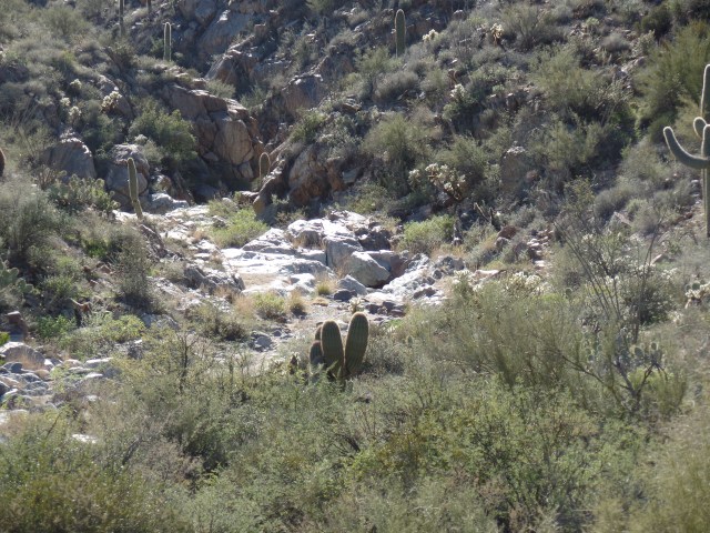
This segment of  trail is easy- to -moderate, and has no outstanding features, other than the dry, grey limestone of the Agua Fria Riverbed, about 3/4 of the way to the loop.

SAMSUNG CAMERA PICTURES

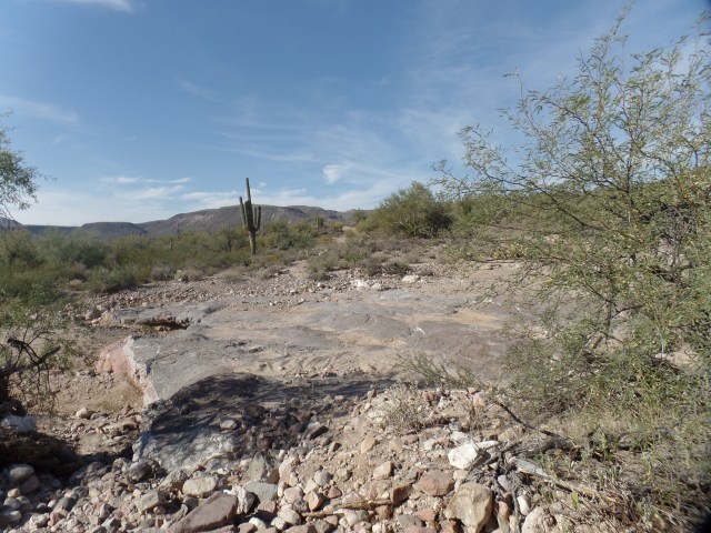
Table Mesa itself lies about two miles west of the BCNRT, and is one of several such flat-topped promontories in this region.

SAMSUNG CAMERA PICTURES

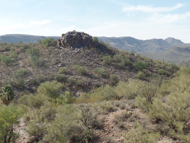
There are a few smaller outcroppings nearby, such as the one below, which could easily have served as a hideaway or vantage point, during the conflicts between Apaches and white settlers, in the 1870’s.

SAMSUNG CAMERA PICTURES

Williams Mesa, to me, the most majestic of the area’s tablelands, lies another 3 miles northward.  It will be the focus of my second hike here, most likely in early November.

SAMSUNG CAMERA PICTURES

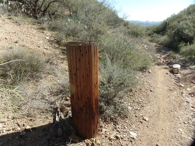
The route for the loop is marked by a single green flat pole, with Williams Mesa Trail as the west route and Little Pan Trail as the east route.  It will wait, patiently, until I can devote a full Saturday or Sunday.SAMSUNG CAMERA PICTURES

The drive back was most sobering: The aftermath of the 24-vehicle pile-up, which resulted from a cattle hauler, whose brakes had apparently failed, losing control, was still very much in progress,at 3:40.  As several drivers made the wise choice to double back northward, and go around through Prescott or Camp Verde, to return to the Phoenix area, the northbound lanes of I-17 and the westbound Hwy. 69 were slow going, as well.

It was great for our area’s restaurants, though, including my dinner-time choice, Leff-T’s Steak House, always a laid-back and gracious place for a burger or fine steak. I’d been away from there too long, and crowds don’t bother me, so the Ranch Burger, salad and plenty of iced tea went down well, as several Phoenix-bound people took in several NFL “games of the week”, and the waitresses bantered with the regulars.

Black Canyon Trail: Ever Glorianna

9

January 17, 2016, Black Canyon City-  With the snow along Prescott Circle Trail slowly turning to mud, I determined that today was as fine a time as any to resume my journey down the Black Canyon National Recreation Trail.  Last spring found me stopping at a ranch in Bumble Bee, an old mining town-turned-have for off-gridders.  About a mile further east, along the old Crown King Road, lies Glorianna Trailhead.  It was there that I began today’s marathon:  12.5 miles, round trip, to Black Canyon City and back.

The crew of All-Terrain Vehicle enthusiasts, who greeted me at the trailhead, confirmed that this was the route I needed to follow-  a fact I had determined from looking on the BCNRT website, earlier.  It’s always good to have locals know where one is headed, the fantasy goons in “Deliverance” aside.  So, I bid them a fine afternoon, and headed out.

SAMSUNG CAMERA PICTURES

Granite tower, near Glorianna Trailhead, Bumble Bee, AZ

Above, I encountered a cholla cactus, shimmering in the afternoon sunlight, a group of sahuaro, seemingly on the march, and, upon climbing a ridge, my first trailside view of Black Canyon City, still four miles further southeast.

The shared use portion of the trail ran for about two miles, before it split off from the road, and headed uphill, just west of the small shooting range, where a very focused young man was practicing,  and thankfully facing away from me.

About thirty minutes later, I came upon one of the two big treasures of the route:  The Agua Fria River.

SAMSUNG CAMERA PICTURES

View of Agua Fria River, from a ridge to the northwest.

This used to be privately-held ranching land, and the old fence posts dot the trail.

SAMSUNG CAMERA PICTURES

Old fence post, about a mile west of the Agua Fria.

The river needed to be forded, but as you can see, the shallowness made this a minor task- and it was rather delightful.  The cast and stunt people of “The Revenant” would have been rolling on the ground laughing.

Just before I made my way down to the flowing stream, the ruggedness of the upper branch of Black Canyon presented itself.

SAMSUNG CAMERA PICTURES

Upper Branch of Black Canyon, north of its namesake town.

Above are two views of the Agua Fria, before I crossed (right) and after (left).  Just after I forded, a mother/daughter hiking pair came down from the south rim, accompanied by their protective 1 1/2 year-old-German Shepherd, who let me know my presence was not appreciated.  The women were more gracious, though, and held the youngster by her collar.

Onward and upward, I headed towards the canyon for which the town is named.  It is a far more interesting sight than I had previously thought. On the lower right is one of the four spur canyons which one encounters along the Horseshoe Bend subsection of the Glorianna.  On the lower left is a good view of the limestone “wall” which distinguishes Horseshoe Bend.


The canyon itself, which will be the focus of further exploration, next Sunday, is seen again, on the lower right.  I got a nice zoom shot of a cylindrical edifice that rises about three miles east of Black Canyon City, from the vantage point of Black Canyon’s north rim.

So as to get back to the wide road before dark, I did not tarry long at Horseshoe Bend, before heading in reverse.  Below are three examples of the mineral beauty to be seen along this trail section.

I encountered the three female hikers again, on my way uptrail, after recrossing the Agua Fria.  Dog was no happier to see me than she was the first time, but no matter.  I also met the ATV group, once back on the shared-use part of the trail.  They had been concerned for my safety, and once it was established that I was fine and knew where I was going, they headed on their way.

There are enough loose ends to be explored around Horseshoe Bend, that I will return here next weekend.  Stay tuned.