The Road to Diamond, Day 101: A Book In The Rocks

2

March 9, 2025, Yuma- Many years ago, one of my students told me that it would be very worthwhile to visit Picture Rocks Petroglyph Site, on her father’s reservation: The Tohono O’odham Gila Bend Band, about 20 miles west of the transportation hub known as Gila Bend.

I spent an hour or so with my overnight hosts, talking of a variety of topics, then went to Penny’s grave site. There, I found that the water for flower vases has been turned off and the restrooms at the National Cemetery have been closed. Whether this is part of the DOGE downsizing, or merely a water conservation measure, is uncertain. I just used some water I had in the Sportage, and left the flowers in vase at my angel’s site.

I found that my excess energy needed to be brought under control-with several little hiccups occurring, while I was fueling the SUV. So, a few deep breaths later, I was good to go. Traveling along some back roads towards I-10, and over to Buckeye, then down AZ 85, I had ample opportunity to get a grip on any impatience that may have been under the surface, and managed quite well. I’m sure that those on the receiving end of my patience were quite grateful.

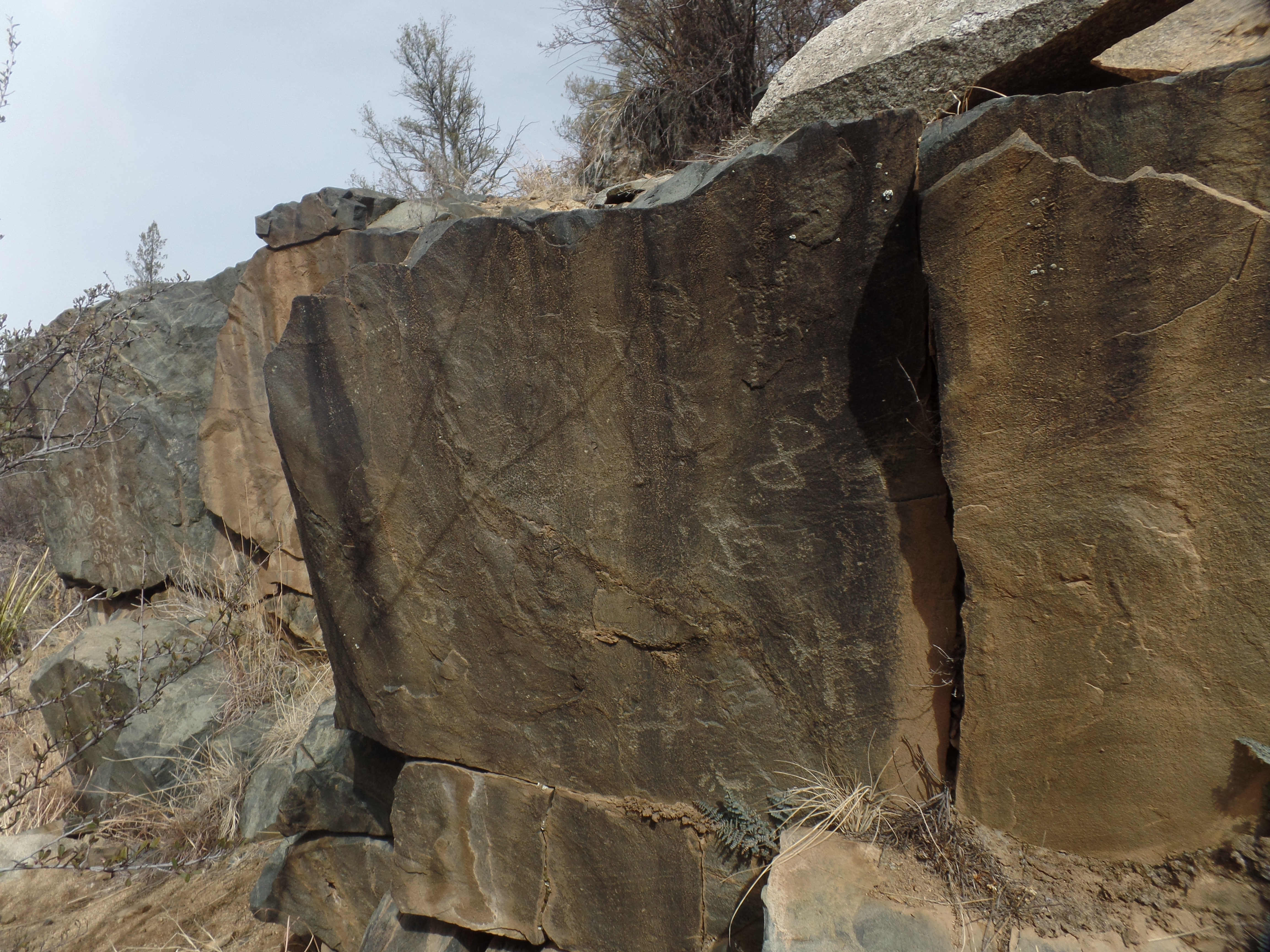
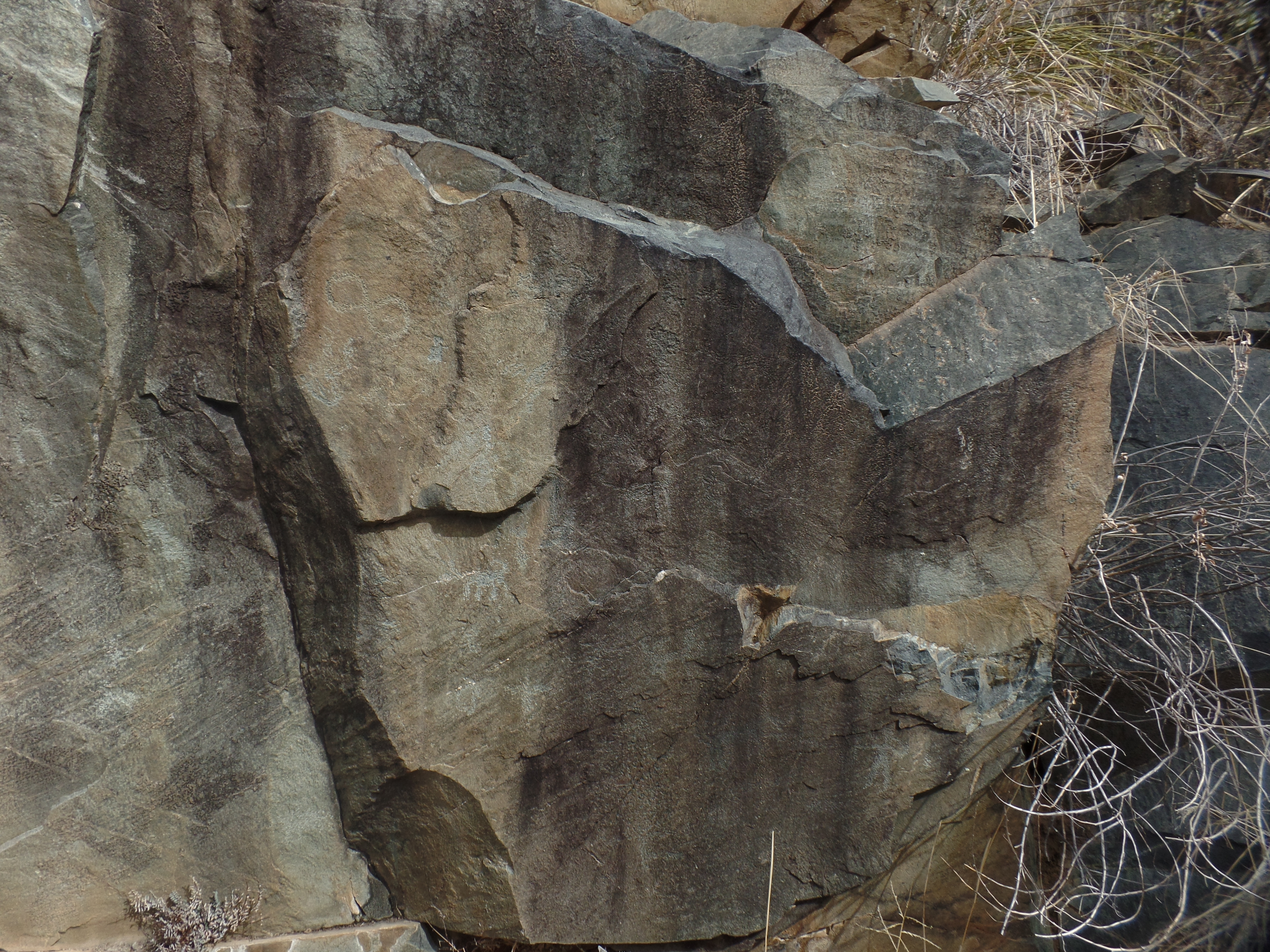
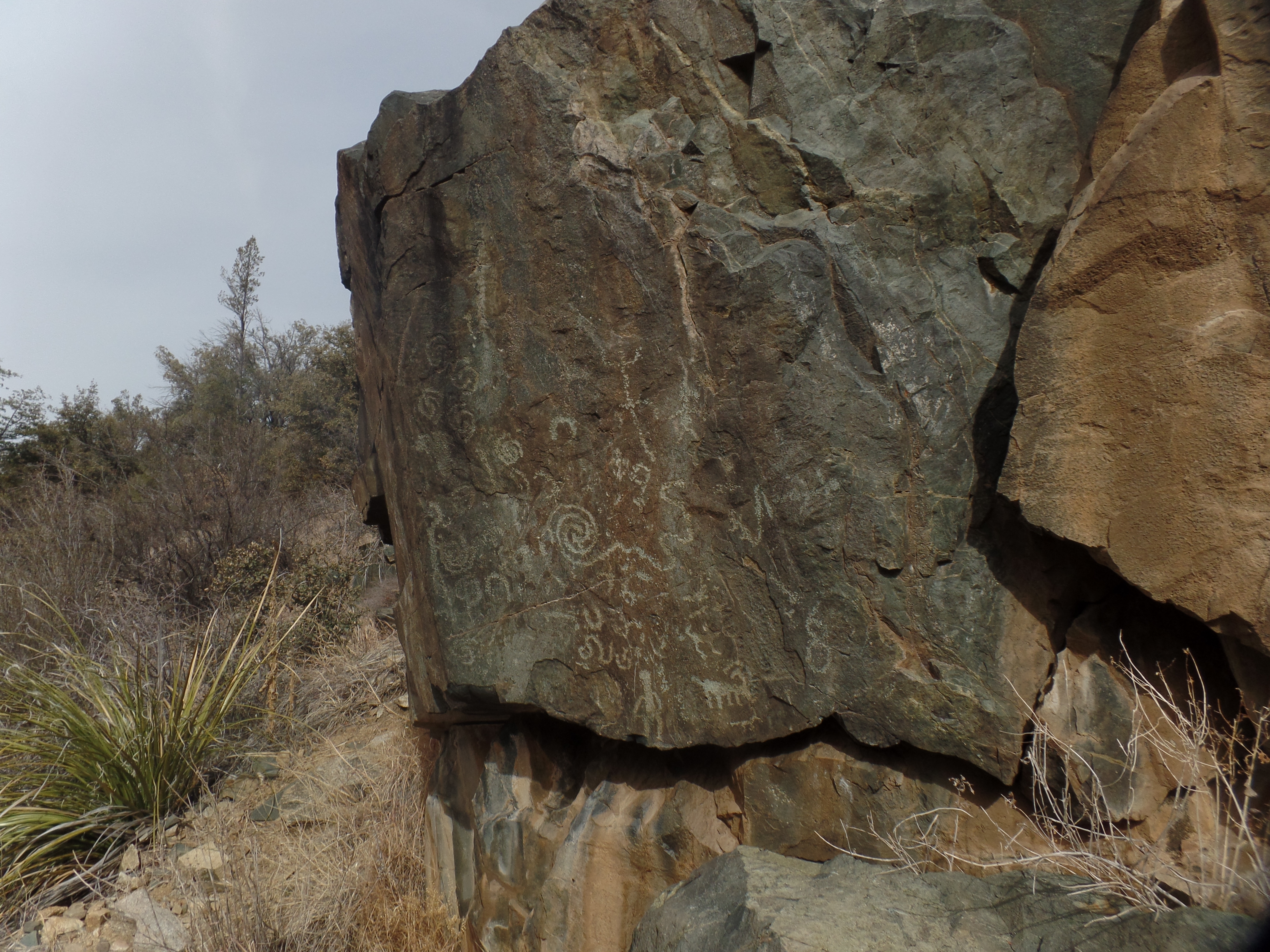
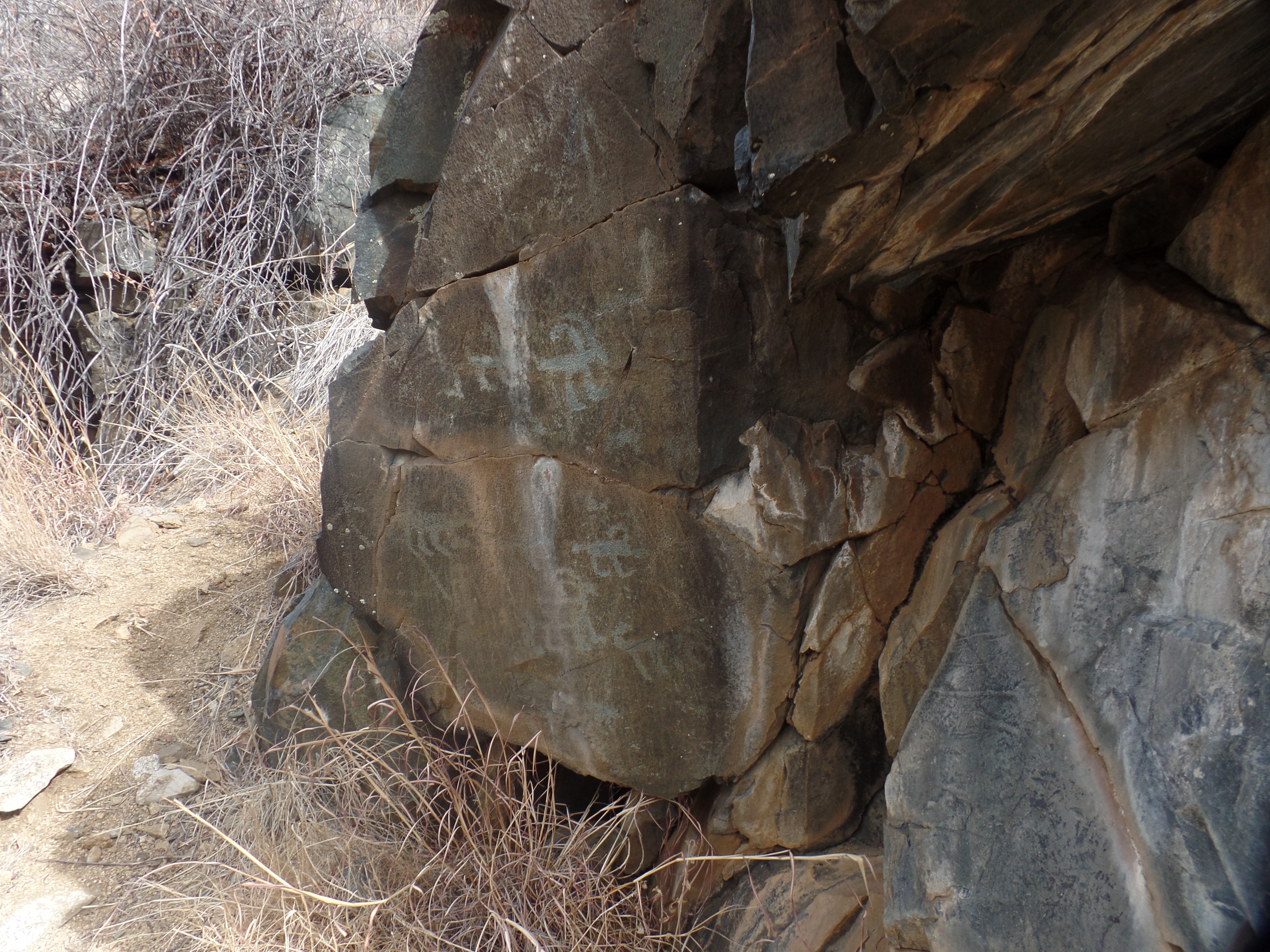
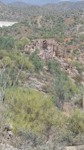
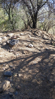
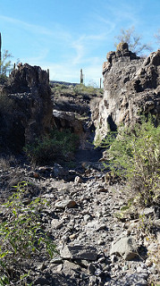
I stopped at Picture Rocks, some 33 years after my student told me about them. It is a hidden gem, and then some. The petroglyphs are of two styles: Archaic, meaning they are primitive and were done by people who lived there before the Huhugam (ancestors of the Tohono and Akimel O’odham) and Gila, the work of the Huhugam. I walked around in amazement at the wealth of drawings on the south side of the rock mound, from its base to its summit. For whatever reason, there are no inscriptions on the west or north sides of the mound. It is fortunate that the mound is cordoned off, and visitors look at the petroglyphs from a short distance. Thus, there are no “Becca loves Jamison, 2022” and such.

Here are six of the scenes that I found at Picture Rocks.

Man vs. Bighorn sheep, Picture Rocks, AZ

A hunting expedition, Picture Rocks, AZ
View of the summit, Picture Rocks, AZ
Busy day in the village, Picture Rocks, AZ
More busy times, Picture Rocks, AZ
News from bottom to top, Picture Rocks, AZ

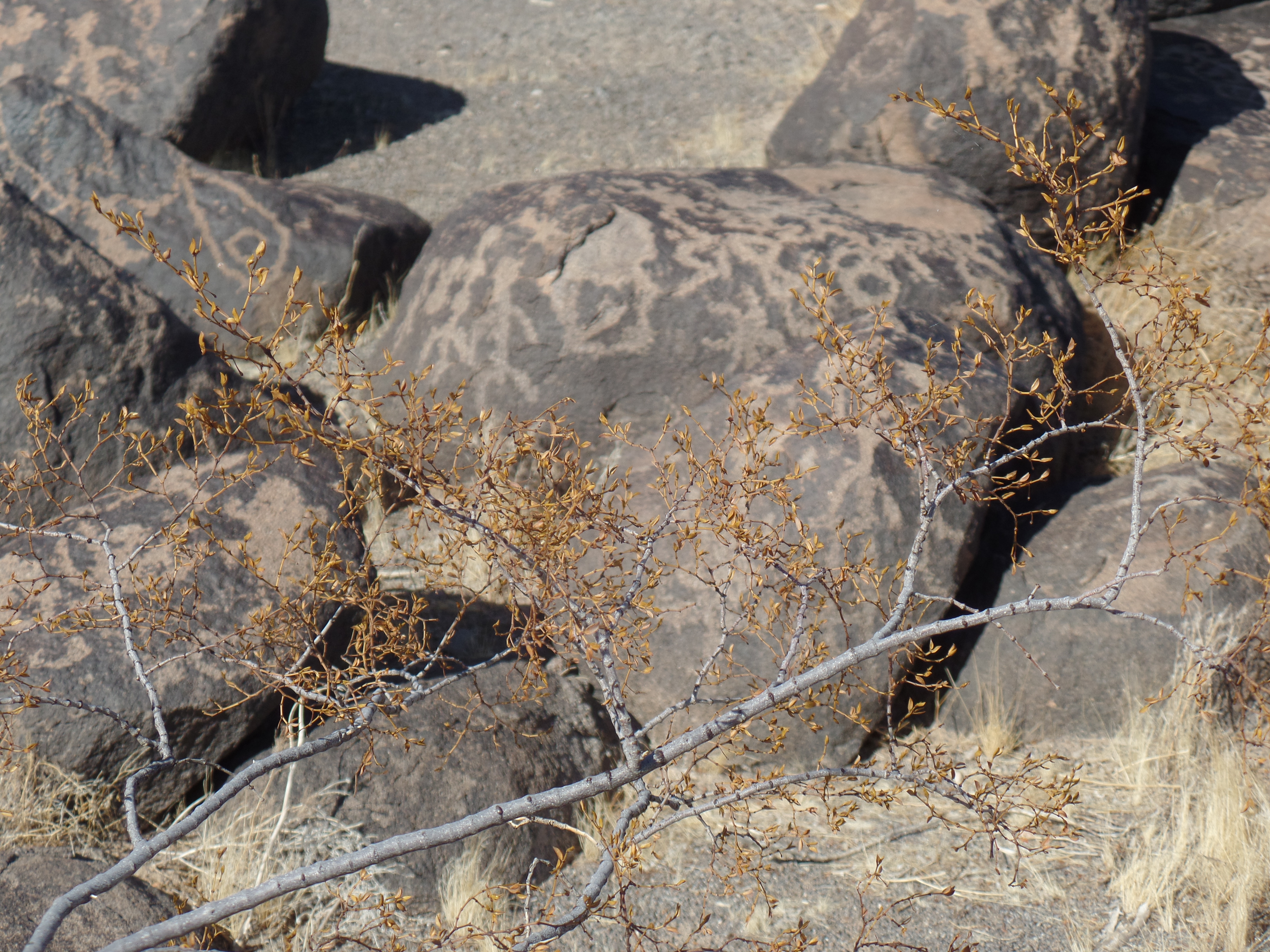
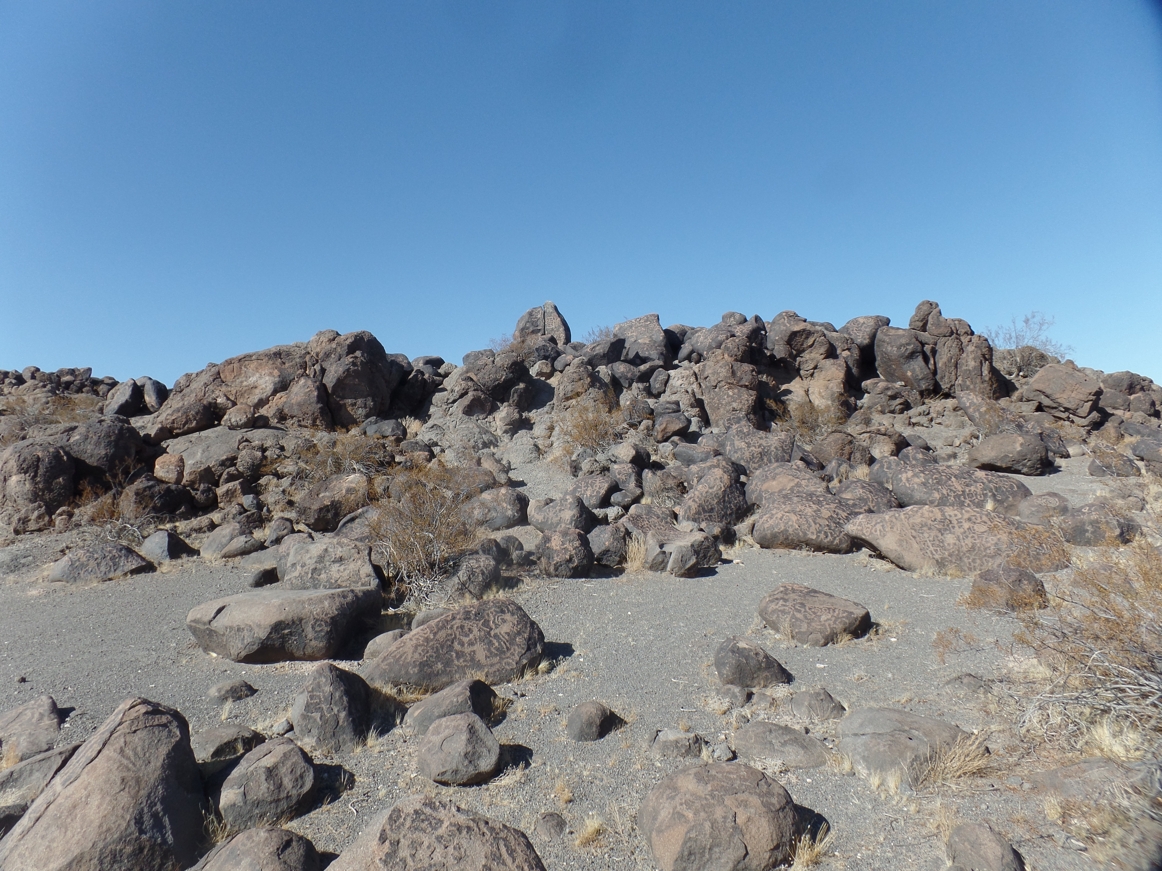
The scene is best viewed in person, but you get the “Picture”. (couldn’t resist).

Salida Gulch’s Legacy

0

February 23, 2024- The images are still clear, after so many centuries: Big-horned sheep, dogs and dancing figures, presented in a small rock outcropping, possibly selected by the Huhugam people who once lived here, at the northern end of their realm, because of the smooth surface area of the slate.

My hiking buddy and I came here this morning, and found the petroglyphs, for which we had been searching for close to ninety minutes. We had gone up and over Salida Gulch, coming close to its junction with Blue Ridge Trail, then heading back towards the trailhead from which we started. About two miles further, there the images were, calling to us from a bygone millennium.

Infinity, a dancing figure and pronghorns- Salida Gulch Trail
Big-horned sheep and mystical symbols
Dancing figure, big-horned sheep spirals and possible snakes
Multiple big-horned sheep and what appears to be a mountain lion

This sort of find is one of the things that make hiking in the Southwest so very rewarding. The glacial residue, by itself, is another. Rocks and boulders are everywhere, along the paths carved by glaciers during the last great Ice Age. Here is a standing stone, reminiscent of Carnac, or Easter Island.

Another “sentinel”, left by glacial retreat.

There will be more such scenes, as March and April play out, here in Home Base I.

The Power of Farsightedness

4

March 19, 2023- I stood atop a small hill, this afternoon. It was the site of a settlement of the Huhugam (also spelled Hohokam) people, at what was the northern edge of their settlement. Salida Gulch is an area where one may take any one of five trails, most of which go up and down fairly steep hills. I went up and down three of them, as a cardiopulmonary exercise-but I digress.

The promontory has a clear 360-degree view, and so was very likely an outpost for sentinels, who kept watch on behalf of villagers living in the creek valleys below. If there were rivals, adversaries or even friendly visitors on the move, over Mingus Mountain to the east, the Bradshaw Mountains to the south, the Sierra Prieta and Granite Mountain to the west, or the forested valley of Granite Creek, to the north, these would easily have been spotted.

The sentries made homes here, and the excavation and retrieval of household implements, when this site was first uncovered by archaeologists, early in the Twentieth Century, indicates that their families stayed in the area as well-contrasting their security system with those more conventional to our own time, in which security patrols live apart from their loved ones, whilst on duty. Recalling that the ancient Aboriginal People had no wheeled vehicles or large draft animals, as far we presently know, the relative proximity of families to sentry sites is quite logical.

The physical farsightedness of these ancestors of the Yavapai, and other central Arizona nations, reminds me of the power that each of us, in our time, can exercise by social and spiritual foresight. Seeing looming challenges, and moving to face these, is needful of 360-degree vision, as well as the presence and support of those closest to us. These features take time, energy and attention-with the requisite maintenance of health and well-being, both physical and emotional.

The larger challenges of life on Earth are not overcome by insistence on one’s own way, by hiding from the world or by seeing oneself and those immediately tied to self as somehow separate from all others. Only through an inherent sense of unity may things like climate change, the attainment of true social justice and the rebuilding of society in such a manner that neither the extremes of wealth and poverty nor the dominance of nations by one self-appointed entity or small claque be faced and the inherent strengths and goodness of humanity be brought to the fore. All people and points of view must be heard, considered, and the most useful ideas brought into the mix.

These thoughts occurred to me, in that time of solitude, atop the small hill, above Salida Gulch.

Broken observation platform, Salida Promontory

Table Mesa, Part III: Little Pan Let Me In

4

November 6, 2016, Black Canyon City-  As I rounded a bend, in the access trail to Little Pan Loop, this afternoon, I became a surprise visitor, to a local resident.

30195562533_7ecef46026

The juvenile Gila monster was a bit bemused, but after a few minutes, it moved off the trail and watched me from some brush. It was a good reminder that reptiles find the early November weather perfectly satisfying, and I watched for rattlesnakes, as well.  None appeared, though.

After a quick crossing of the South Fork, Agua Fria, I found the southern turnoff to Little Pan Trail, and moved along, passing the Royal Throne, which overlooks the river,

30714412392_ecb3836332

then across the Agua Fria itself, taking time to wander a bit around the mesquite and saguaro forests that line an island, in the middle of the riverbed.

30195813563_288bcec659_n                                          30199205884_461a152910_n

Little Pan Wash is not on the main trail, but it makes for an interesting side trip.

30794226516_9b3bb7290b_n

It is one of the areas that was heavily mined, in the early 20th Century.  Little Pan Mine, upstream on the Agua Fria, is still accessible to an intrepid visitor.  I did not seek it out, this time.

About twenty minutes after leaving Little Pan Wash, I came upon the overarching attraction of this trail:  Agua Fria Fort, near the northern end of Little Pan Trail.  A side road takes the visitor to this remarkable fort, built by the Huhugam people, as one of their northernmost places of settlement.

30529847110_9cce98db5c_n30794212606_ebb95b850b

30742986821_debd505246                  30830719765_dfdc00678d

After examining this durable fort, from three angles, I walked quickly to the point where Little Pan meets Williams Mesa Trail, and the main Black Canyon Trail towards Black Canyon City.  It was there that I headed back, along Little Pan, towards the trailhead.

Thus ended my first visit to this lush, exquisite and challenging area, past which I have driven, so many times.  There remain three sections of the Black Canyon National Recreation Trail for me to explore for the first time.  Next up is a foray from Table Mesa trailhead to Boy Scout Loop.  After that, Boy Scout Loop to New River Road, and New River Road to Lake Pleasant Road, will take me through lower-lying Sonoran Desert terrain, to the edge of Phoenix.  It will represent some 88 miles of hiking, over a two-year period, and will be my longest completed route.