The Flip-Flop, Day 6: Lassen Volcanic National Park

2

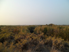
After shaving by using my side view mirror, and saying a few prayers, I left Lake Britton and had a decent breakfast at Fireside Village, in the small town of Hat Creek, CA.  The creek for which the town is named is an integral part of the Mount Lassen drainage area, as is Kings Creek.

I arrived in Mt. Lassen Volcanic National Park around 9:30 A.M. and spent six hours there, enjoying the contrasts- from lushness to austerity.

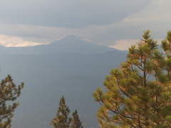
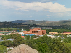
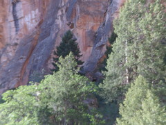
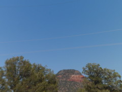
We are greeted almost immediately by the great peak, with plenty of the legacy of its 1915   eruptions, much in evidence.

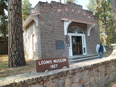
I looked around Loomis Museum, which features a seismograph that records all tectonic activity in the area, with photographs taken by B.F. Loomis, right after the eruptions of May 19 and 22, 1915.  Comparative photos are also shown of the area, both before the eruptions and several years after.  It is noteworthy that Lassen Peak is the southernmost volcano in the Cascade Range, with the Sierra Nevada beginning closely to the south.

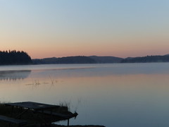
Not far from the museum is Manzanita Lake, which, along with the aforementioned creeks and other lakes to the north of Lassen, sustained several Native American tribes  in the area.  Native crafts are well-displayed in the museum, along with the story of Ishi, the purported last member of the Yahi Tribe, who lived west of Lassen Peak.

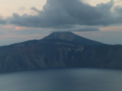
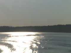
Here is a view of Manzanita Lake.  If I come back to Lassen, it will be to spend a couple of days in a cabin at Manzanita Lake.

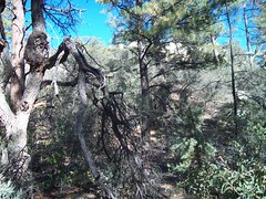
The forest has suffered this past summer, from lightning-caused fires.  There are several areas of the park that are still closed to the public, and fire crews were much in evidence along the main park road.  West and north of Summit Lake is the main hot spot area.

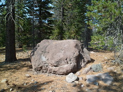
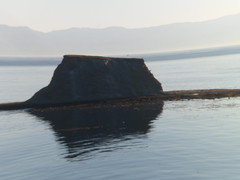
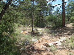
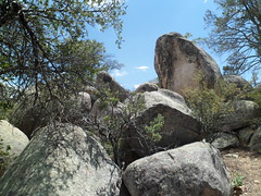
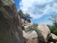
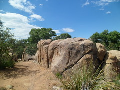
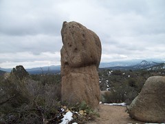
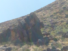
Still, the damage caused by rock and magma far surpassed that done by forest fire.  Here is a rock field, just east of the Manzanita Visitor Center.  There are four basic types of rock at Lassen:  Basalt, andesite, red dacite and gray dacite, (shown below).

Lassen Peak may be hiked, to a point within 1,200 feet of the summit.  After that point, the tuff underfoot becomes too treacherous, and is thus closed to hikers.

Several boulders are on display in the Devastation Area, site of the worst damage from the May 22, 1915 eruption.  Below is a red dacite specimen.

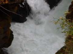
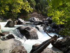
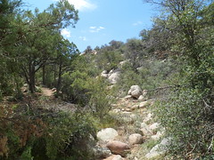
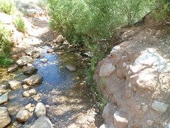
Below, is Kings Creek.

I spent an hour or so in the Summit Lake area, enjoying a light lunch and another beautiful lake.  An 11-mile hiking loop is available from Summit, on another visit.

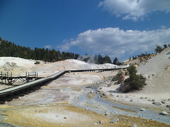
The piece de resistance, however, is an unexpected sight, with an even more unlikely name:  Bumpass Hell.  Kendall Bumpass, a cowpoke from Hat Creek, found this area of mud pots and boiling springs, which have an average temperature of 200 degrees Fahrehheit, in the 1890’s.  He lost his own left leg to an unstable patch of boiling soil.  Bumpass Hell is the largest of five hot spots in Lassen Volcanic National Park.

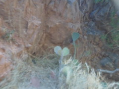
At the edge of heat and sulphur,  small plants, like this purple heather, thrive in patches, uptrail from Bumpass Hell.

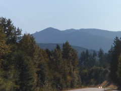
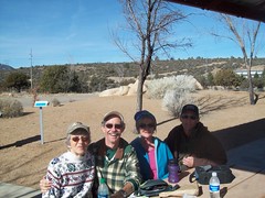
I would spot more awe-inspiring scenes, beyond Lassen, in the Spanish Creek/Feather River Gorge area, north of Lake Tahoe, on the way to Reno, and another visit with my friends.

Lassen Volcanic National Park was the fourth California site to be designated a national park.  It remains among the most eclectic.

The Flip-Flop, Day 5: Rogue River Valley and Elizabethan Ashland

0

Monday, Sept. 24, found me waking up in one of the finer places in which I’ve stayed, hotel-wise.  Union Creek Resort has several cabins, which are in reality country houses, along the upper Rogue River, east of Prospect, OR.  I could easily stay here for several days and just relax, albeit sans TV- which I have done more often than not this trip, anyway.  Here is the cabin I used the other night.

The folks here were as gracious and helpful as any I’ve met, anywhere in the world- and the Rogue River Gorge is a spectacular backdrop.

It’s quite apparent why the Rogue is a favourite of white water rafting buffs.

I stopped briefly downriver, at Mill Creek Falls, closer to “downtown” Prospect.

The Rogue River defines so much of what makes this southwestern sliver of Oregon’s interior. One could easily, as I said initially, spend days in relaxation and meditation.

I continued, through bustling Medford, to the laid back ambiance of Ashland, interior  southwest Oregon’s southernmost town, and a haven for theater, especially Shakesperean theater.  The Ashland Springs Hotel is among the tallest buildings between Portland and Santa Rosa, if not San Francisco.  I waited briefly here for my friend to appear.

The staff here were very warm, in greeting the various guests, and phone inquirers, who happened along while I was waiting.

Once Jody arrived, we went by the Elizabethan Theater, and its two satellite theaters.  This is the nation’s oldest Shakespearean venue, and is an outdoor theater-in-the-round.

The Shakespearean Festival takes place for several evenings, right around this time in September.

We had a fabulous lunch at Greenleaf Restaurant, along Ashland Creek and in the central plaza.  It was hot in Ashland that afternoon, but the creek made a big difference in comfort level.  I will caution against drinking much, if any, of the lithium water that is available on the plaza, for tasting.  I gave it a shot, in sporting fashion, with no ill effects. Lithium water is what it is, though.

After lunch, before Jody had to leave, we sat in Lithia Park, by a duck pond, and discussed life in general.

After Jody left, I went back to Lithia Park and explored a bit further.  Some resident deer had captivated a woman, who was hiding behind a post, so as to get several photos of the creatures.  I found a blind of my own, and took the animals’ portrait.

There are numerous small gardens within Lithia Park as well.

My days tend to start early, get taken up longer than I expect, with posting and other aspects of my routine (praying, etc.), so before I know it, it’s mid-afternoon. I returned to my car, gassed up and headed towards Mt. Shasta and the small town of McCloud, CA. , which sits serenely at the great dormant volcano’s foot.

Here is a northern view of Mt. Shasta.  Below, is McCloud Hotel.

Mt. Shasta is more clearly visible from this southeast viewpoint.

Finally, I found Lake Britton, and a campsite operated by Pacific Gas & Electric Company, on forest service land, east of Mt. Shasta. This gave me the perfect amount of solitude, which I rarely crave, but needed on Monday evening.

Next up:  Lassen Volcanic National Park.

The Flip- Flop, Day 4: Oregon’s Volcano Alley

2

Leaving the Central Oregon KOA, in Culver,  just north of Redmond, my itinerary for the day was Bend and Crater Lake, with an overnight stop somewhere in the Rogue River Valley.   I did  not figure on three of Oregon’s best kept secrets. Ogden Memorial Park, on the south edge of Culver, captures Crooked River Canyon.  It is named for Peter Ogden, the hero of the Whitman Massacre and founder of Ogden, Utah.

Also memorialized here is Navy Lieutenant Rex Barber, a native of Culver, who shot down the airplane carrying Admiral Yamamoto, in World War II.   Smith Rock overlooks the town of Terrebonne, just north of Redmond and Bend.  Here is the middle of Volcano Alley (my term for central Oregon), with Mt. Jefferson and the Three Sisters winking back, from the west.

 At Smith Rock State Park, hundreds of Oregonians and visitors busied themselves with hiking, jogging, rock-climbing and just plain gawking, in an environment not unlike several in central or western Arizona.

Smith Rock, OR
Crooked River Bridge, Culver, OR

Below, is the aptly-named Crooked River. Rock climbers were numerous, on this bright, blessed day.

I hiked down to the river and along its banks for a while, before heading to Bend, central Oregon’s burgeoning hub.  

Crooked River, at Smith Rock, OR

Bend has a fine reputation as an interesting recreation center.  Stopping for lunch at Sidelines Sports Bar & Grill, I was not disappointed.  Yes, they have great lemonade, as well as superb food.  I learned something new about Oregon- there are lots of Arizona Cardinals fans here.

Below is Brooks Park, along the banks of the Deschutes.

I soon found myself in another unexpected treasure:  Newberry Volcano National Monument.  This is one of a few national monuments run by the US Forest Service, rather than by NPS.  I took the road to the top of a cinder cone, in the North Unit of the Monument, and spent a little time near the Visitor’s Center, afterward.  This volcano exploded some 7,000 years ago.

The Middle Sister comes into view, from the top of the North Cinder Cone at Newberry.

On my way to the car, a little park resident was busy with its supper.

The day drew to a close, with a near-perfect sunset, at chilly and gorgeous Crater Lake, Mount Mazama’s gift to posterity.

The only drawback of being on the north side of this quiet gem at sunset is- the lake is not in the foreground.  It is still a thing of beauty, though.

These days, one after another, have been amazing. Next up:  The Rogue River Valley and northern California’s own Volcano Highway.

The Flip Flop, Day 2: Along Washington’s “Knife Edge”

0

The last day of summer stirred, fresh but still very smoky, in East Wenatchee.  I had the pleasure of staying overnight with these fine folks.

After freshening up, breakfast, morning prayers and writing my Seattle post, I was off to see the condition of Wenatchee, in the ongoing struggle with relentless smoke.  It was not as thick as yesterday’s, but visibility was, as yet, not too good.  Nonetheless, I stopped at Riverside Park, for further prayer and reflection.  This could be any misty morning, along the Columbia River, but the smoke was palpable still. The air was a bit clearer when I got to Wenatchee’s centerpiece, Ohme Gardens, on the north side of town. There is a complete arrangement of nature here:  Great trees, flowers, rock, water, and manicured Victorian-style lawns.

Just outside Ohme Gardens is a stark reminder of Wenatchee’s location, at the divide between the green Cascades and the brown that covers much, but not all, of the Palouse.

The interplay between the Palouse and the Columbia River is much in evidence, in the area between Wenatchee and Quincy, the next sizable town to the east.

As I got past the bustling city of Yakima, I spotted Yakama Nation Cultural Center, in Wapato.  This fascinating culture would be well worth a trip north, in and of itself, one of these days.  Alas, the center was about to close when I got there.  The motels I checked nearby were far too pricey and there was no camping in evidence anywhere nearby, so I moved on.

I made a brief stop at Toppenish National Wildlife Refuge, before continuing on to Goldendale.  This wetland is vital to sustaining the web of life in a largely dry area  north and east of the Cascades.

Next:  Goldendale, Columbia Gorge and on to Bend, OR.

Northwest by North, Day 13: Lake Ozette to the Puget Sound Ferry

2

In the 1980’s, Penny and I made a list of places we wanted to see together.  The idea of a trip up the coast, “The Whale Trail”, came into our collective mind.  We would go to Santa Cruz, Coos Bay, Astoria, Grays Harbor, Neah Bay, Port Renfrew, the (then) Queen Charlotte Islands and southeast Alaska. Time constraints, continuing education and money issues rained on that parade, and we did make it to Santa Cruz once or twice, but never beyond it.  All these years later, with our son raised and now living his own life, my spirit-soul mate and I finally made it to  Coos Bay, Astoria, the Grays Harbor/ Ocean Shores region and, Tuesday morning, to Neah Bay. I spent Monday night sleeping under the blessed stars at Lake Ozette’s  Lost Resort.  Once or twice, I awoke during the night, glanced up and saw two stars directly above me, looking like a pair of eyes.  Just before dawn. I awoke for the day, looked up, and saw one star, appearing like a heart beaming down at my heart.

Upon getting myself together, I went up to the office and found Lost Resort’s owner, who was somewhat befuddled that anyone would be up and about at such an early hour. There were, actually, about six of us wandering about.  He took my payment, excused himself and I also moved along, to photograph my surroundings. Below is Lake Ozette itself.

The owner left a message for all who came while he was gone to Forks.

So, on do we all go. I headed up the hill to Neah Bay.  Along the way, there are views of the Straits of Juan de Fuca and of Vancouver Island.

I was glad to find, open for business, the Warmhouse, upon arriving in Neah Bay.  The Makah people mean it, when they say “Welcome”.  Of course, there is a $10 fee for using the trails, but it’s good for a year.

After biscuits and gravy, coffee and a bit of conversation with some of the Makah and a pair of motorcyclists from Idaho, I went on towards Cape Flattery, the northwestern-most point in the contiguous 48 states.


First, though, a stop was in order at  Fort Nunez Gaona DIAH Veterans Park.  This spot pays homage to the brief occupation of the area by the Spanish in the 1760’s (thus, the name Juan de Fuca being attached to the strait just north of here, as well as the San Juan Islands, at the north end of Puget Sound.).  It also lists the names of every Neah Bay resident who  has served in the nation’s military, living or dead.  “Diah” is the original Makah spelling of Neah Bay. Below is a view of Neah Bay itself.

Those with several days to spend here may hike down past Hobuck Beach, to Shi-shi Beach and the old settlement of Ozette (U’cit, in Makah), which was the original home of the Makah people, west of the present-day lake of the same name.  Neah Bay was the U. S. Government’s established reservation site for the Makah.  Ozette gives me a reason to return, someday. Cape Flattery Trail is largely planked, making the area easily accessible to many who would otherwise have difficulty.  It is  a 3/4 mile journey, each way.  

Above is the trailhead to Cape Flattery.  Below, is the split between the north and south points of the cape.  

Here are some of the sea caves which riddle Cape Flattery, and which may be the downfall of the cape above.

Just off the Cape, lies Tatoosh Island, a gull nesting site, which is also sacred to the Makah.

  I spent about forty minutes at the Makah Cultural Museum. at the north end of town.


After bidding farewell to Neah Bay, I headed for the Straits Coast, towards Port Angeles.  The first town one encounters on this route is Sekiu.


Along the way, there are views of the Olympic Range to the south.

Port Angeles is a major hub for the Straits Coast.  Here, one may take a ferry to Victoria, BC.  

Here, people come from all over the northwestern corner of Washington to meet their supply needs.  Here, one may swim in the Strait.   I visited Feiro Marine Life Center, and met the resident octopus, among other tenants.

East of Port Angeles lie Sequim,  Jamestown, and Sequim Bay.  The s’Kallam people are stewards of this area, much as the Quinault, Hoh, Makah and other peoples are along the west coast.

Lastly, the evening found me on the ferry from Bainbridge Island, on the west side of Puget Sound to Seattle.

So went another full day, on yet another block. 🙂

Prescott’s Centennial Trail- The Northern Spur

0

Friday afternoon found me in search of petroglyphs.  I knew they would not be as extensive as those of Mesa Verde or Bandelier, but they are our local link to the Sinagua people.

The first part of the northern spur is uphill. The uphill is not steep, and leads to a ridge, giving a fine view of Granite Mountain and Thumb Butte, plus all in between.

Of course, there is no direct trail from here.  One would encounter several subdivisions along the way.

I crossed a dry wash bed, in between the two hills which make up the trail.

Going along towards the site of the petroglyphs, one encounters several limestone fields, as was true of the southern spur.

Once past these, there is a slightly-flowing North Fork of Miller Creek, as the water emerges from underground.

Then, a short climb over some other rocks leads to the final boulder field, and the petroglyphs.

The petroglyphs are faded spirals, with a barely visible upright figure on one of the boulders.

As I left the petroglyph area, I noted what looked like the head of a snapping turtle- petrified for posterity.

 The  trail is easy enough to do in one hike, on a cool day.  This being the monsoon season, I found splitting the trail in two was the best course.

Prescott’s Centennial Trail- The Southern Spur

3

Yesterday, I hiked two miles, round trip on Prescott’s newest trail- The Centennial Trail, which runs along a limestone boulder field south of Thumb Butte and west of uptown Prescott.  I took the southern spur, which gives views of the Bradshaw Mountains, Miller Valley and downtown.
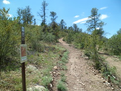
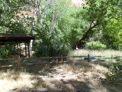
About 1/4 mile along, one comes to this wooden bridge.

The following are some noteworthy limestone fields heading up to the overlook.

At the top of the South Spur, one may view midtown, just across Miller Valley and the Bradshaws,to the southeast.

The most visible building above is Yavapai Medical Center- Prescott Campus.

Off to the west, just past the overlook, below, there is a formation that somewhat resembles the Sphinx.

There was not a whole lot of water flowing, but the stream which is crossed by the trail is the North Fork of Miller Creek, which is not swiftly flowing, even in the wettest of seasons.

Next up:  The Northern Spur of Centennial Trail.

Scenes from A Group Hike, June 24, 2012

2

This morning, eight of us peeps and a dog went on a 2.5 mile hike, in the Groom Creek area, southwest of Prescott.

8289324573_61fff57e64_m

We found the usual boulders, juniper pines, ferns and one lonely coriopsis.

Here are the photos I took, on this beautiful, if hot, morning.

8233990476_4f21ba26de_m

8274113596_5db4788a47_m

8274111408_541bac3af9_m

8273041645_039c4df93f_m

We had a grand time, though it was hot, towards the end.

8287718675_0b83d1df35_m

8296262182_bf79dc2a8a_m

Back to Bright Angel, June 19-20, 2012: Part 2

2

The warning sign is very clear: “Down is optional.  Up is mandatory”.  I was determined I would get to the Colorado River and back, within one 24-hour time period.  There are things one can do to make that happen- drink the water that is available at three locations along the way, soak the shirt and hat, copiously. (Women can do this, discretely, and most of us men are gentlemanly enough to turn ourselves away).  Lastly, take advantage of the four rest houses and numerous rock overhangs that provide shade.

I set out from Mather Campground at 6:30 A.M., on Wednesday, the “Longest Day” of the northern year.  Greeting several of us at the trailhead were a pair of elk.

8232878851_0194534473_m

The little boy on the right was my steadfast friend on the first 1/2 mile of the hike.  Then he fell back to rejoin his father.

There are 21 more photos in this post.  Bear with me.

8232877653_99b9e5296d_m

I started off in earnest at 7:00 A.M.

8233940084_d570691851_m

The top layers are Kaibab and Toroweap Limestone, respectively.  Toroweap makes the sheer wall one sees just below the surface.

8232875057_b7901bd2b5_m

A few big horn sheep were keeping us company during the first half mile.  There were also mule deer, which were a lot more skittish.

8232873759_a3591226cc_m

8232872413_e5e36002e3_m

We pass through two windows within the first mile of the trail.  Next are two views of the Toroweap Limestone wall.

8233934780_5704b6b740_m

Not far away, I spotted the 1.5 Mile Rest House.  This is very welcome in the afternoon!   Below is a close-up of the rest house.  Those at 3 Mile, Indian Garden and Pipe Creek are quite similar.  Water is available at the first three, and all four have toilets.

8233922998_50e071883b_m

Below 1.5 Mile, there is a solid layer of Coconino Sandstone.

8232858315_c7c8ceb009_m

As I neared Indian Garden, an NPS helicopter landed.  This appeared to be a wild animal transfer of some kind.  The ranger had his tranquilizer gun out, so it may have been a mountain lion, which would not have been welcome at Indian Garden Campground!

8232851027_96763e6127_m

8233907812_354fd4d6a1_m

The Colorado Plateau is largely desert, at its lower elevations.  Indian Garden offers a lush oasis, for about 1 1/2 miles, along Garden Creek.

8232840231_00661a395f_m

Above, Undivided Dolomite and Mujav Limestone are your hosts, heading from Indian Garden to Devil’s Corkscrew.  This rock layer is from the Cambrian Era.

Garden Creek remains a friendly helper, for about a mile past Indian Garden.

8233895848_2e59ea4814_m

Devil’s Corkscrew is a mixture of Zoroaster Granite, Nankoweap Sandstone and Gardenas Lava.  Dox Sandstone makes up the bottom layer, where one gets to Pipe Creek.  This is a 2.5 segment of extreme desert, with triple digit temperatures in the afternoon.  Be fit, or turn around!

8232829697_d9e52b1fc0_m

I took this from underneath a rock overhang, along the Corkscrew.  This postpile is of Dox Sandstone.

8232826775_fe8b5284b7_m

The emergence of Pipe Creek, and the presence of blue dashers, signal that the river is close by.  I tried to encourage a couple of ladies to keep going the last mile or so.  Apparently, they’d had enough.  A man who came by while I was at Pipe Creek Resthouse said he saw them soak their shirts and head back towards the Corkscrew. I never saw them after that, so they made it out. Always follow your gut, in these situations.

8233883406_a6fdac40e0_m

At 11;30 A.M., I reached the Colorado River, at Pipe Beach.  The rock you see along the north bank is Bass Limestone and Vishnu Schist.  This is all the legacy of Pre-Cambrian Earth, when everything lived underwater.

8233879094_8e97711b82_m

I rested, had lunch and soaked my feet at Pipe Creek Resthouse, after chatting with a couple who were kind enough to record my presence (above), and taking their photos, in turn.  It took from 12:15 to 6:38 P.M. to return from the river to the rim.  There were confirmations along the way, and I was constantly reminded of confirmations that I would be just fine.  One of those was a heart-shaped prickly pear cactus.

8233876234_f9b779968f_m

Here are the Navajo Sandstone and Toroweap Limestone layers, in late afternoon.

8232809739_0e63e9d6d6_m

I had the good fortune to meet up with three people from Tusayan, when I got to 3-Mile Rest House.  They pretty much stayed with me the rest of the way.  It was their first Canyon hike, and two of them said it would be their last.  I would be surprised if that were the case.  Cooler weather brings a much different Grand Canyon experience.

I cannot say enough good about the rangers.  These are among the hardest-working young people I’ve ever seen.  They keep very close watch on hikers, and will be the adults in the room, when one’s judgment gets cloudy.  I got through the Longest Day by following their guidelines.  Though traveling rim to river and back on foot is discouraged, it can be done- if one is in good shape, takes his/her time and stays hydrated.

Back to Bright Angel, June 19-20, 2012- Part I

2

I had not been in the Grand Canyon since Penny and I went in June, 1981.  We slept in the open that night.   In 1983, we went for a day trip to the North Rim, but only went about a mile on the North Kaibab.  We took Aram along the Rim Trail in 1996.

About a month ago, I read about the Alzheimer’s Association having a Longest Day campaign, to raise awareness on the plague of dementia.  I didn’t have the money to formally register for the event, but decided to do a hike along the Bright Angel Trail, to make a statement, and maybe better-off people would feel like chipping in, on their own.

So, Tuesday afternoon, I headed north, through Williams and Valle, to the South Rim.  Williams is the southern terminus of the Grand Canyon Railroad, a narrow-gauge system that also goes to  the South Rim, ending at Bright Angel Lodge.

Here are a couple views of Williams.

8232661807_9364100aa9_m

8232660239_4a962b5d5a_m

Williams was named for Bill Williams, a roguish mountain man of the mid- Nineteenth Century, who is also the namesake of nearby Bill Williams Mountain, which I plan to hike over Labor Day weekend.  His name extends to a river which flows from this area into the desert between Wickenburg and Kingman, eventually meeting the Colorado River, south of Lake  Havasu City.

After a nice cup of joe at American Flyer, I headed on to Valle, home of Flintstones’ Bedrock City- a nice diversion for families with very young children.  The outfitters’ supply store in Valle is made up of two pyramids.

8232658675_14b08e5e8d_m

The area from here to Tusayan varies between grassland and pine forest, but mostly has the former.

15179627374_df97e796bf_m

There are occasional buttes, like this one just north of Valle.

8233721116_9f2034020e_m

I got into Tusayan, the service town just southwest of the park, and purchased a few more necessaries, like granola for breakfast and ice for the cooler.  Then, it was off to the campsite.  Like South Carlsbad State Beach before it, Mather Campground was full.  I took my reserved spot, at the tail end of the grounds and jerry-rigged my rodded tent, using twine and string.  It served its purpose and any snickers were kept to a dull roar.  NOTE TO SELF:  Pick up some tent rods next week, before the three-day camp-out.

Here are a few shots around the Mather Campground area:

It’s dry here, so the ponderosas need all the help they can get.

8232655755_555118b0e8_m

At 6:30 PM, Ranger Kim gave a talk on the area’s wildlife.

8233718092_15801e3ab6_m

At 7:15, one of her subjects introduced herself.

8233716502_3c7d9077d6_m

I arrived  at Mather Point, the site of my evening photo shoot, around 7:20.  Here is what awaited.

8232648143_8893e6f783_m

This is Kaibab Limestone, the topmost (for now) layer of the Grand Canyon.

8233708728_127fdf42a4_m

Here is a formation of Navajo Sandstone.

8232641155_ca4d5c3858_m

Various Coconino and Toroweap (Limestone) formations bid farewell to the Sun.

8233703006_903b34216a_m

This ominous looking creature is an outcropping of Kaibab Limestone.

8232635127_8ef6de5c43_m

Coconino Sandstone and Hermit Shale in twilight  were awe-inspiring.  These sights evoke my bird fantasies.

8232627205_e0b8789b5e_m

Sunset at any of the overlooks is a must-see.  Now, for the piece-de-resistance.

8233686274_4a43d129c6_m

This is one of the features that made me fall in love with this canyon.  Next, I will present some of the others.